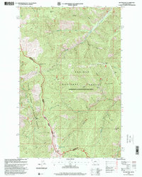
1997 Map of Bloom Peak
USGS Topo · Published 2000About this map
High peaks and deep drainages define this remote section of the Montana and Idaho border, where the Coeur d'Alene National Forest meets the Kaniksu National Forest. The landscape is dominated by notable elevations such as Bloom Peak, Eightyseven Mile Peak, and Minton Peak, the latter featuring a charted Lookout. A complex network of watercourses, including Marten Creek and Trout Creek, feeds into the regional watershed, while a high-altitude Mine and an isolated Heliport suggest the area's history of resource extraction and fire management. Evidence of backcountry navigation is seen in labels like Taylor Saddle and the Recreation Trail, alongside the secluded Ninetythree Mile Lake near the southern border. This 1997 revision of 1960s topography provides a detailed look at the Cabinet Ranger District before modern satellite mapping altered the documentation of these wilderness areas.
Find a feature on this map
32 named features on this map. Tap any name to fly to it.
Don’t see what you’re looking for? This feature index may not catch every label — zoom into the map to look around manually.
Map Details
Editions of this 1997 Bloom Peak Map
This is the sole edition of this map. No revisions or reprints were ever made.
Other maps of this area

1932 · Trout Creek
USGS Topo · 1:125,000

1935 · Trout Creek
USGS Topo · 1:125,000

1936 · Trout Creek
USGS Topo · 1:125,000

1956 · Cooper Gulch
USGS Topo · 1:62,500

1956 · Wallace
USGS Topo · 1:250,000

1957 · Burke
USGS Topo · 1:62,500

1960 · Wallace
USGS Topo · 1:250,000
1966 · Noxon Rapids Dam
USGS Topo · 1:24,000
1966 · Taylor Peak
USGS Topo · 1:24,000
1966 · Bloom Peak
USGS Topo · 1:24,000