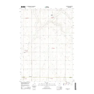
2015 Map of Bloomfield
USGS Topo · Published 2015About this map
Bloomfield sits along the southern edge of this Spink County landscape, marking a quiet agricultural crossroads just above the Spink Co Beadle Co line. The terrain is defined by the winding course of Foster Cr, which meanders through the western and northern sections of the township. In the northeast corner, Hillside Colony represents a distinct pattern of communal settlement typical of the eastern South Dakota prairies, situated near the small Roe Cem and Foster Cr. The map reveals a highly structured section-line road network, where routes like 182nd St and 405th Ave maintain the geometric precision of the Great Plains survey system. Smaller historic footprints like LaDelle appear alongside these rural thoroughfares, providing specific points of interest for genealogists tracing family landholdings in Union Township during the early 21st century.
Find a feature on this map
27 named features on this map. Tap any name to fly to it.
Don’t see what you’re looking for? This feature index may not catch every label — zoom into the map to look around manually.
Map Details
Editions of this 2015 Bloomfield Map
This is the sole edition of this map. No revisions or reprints were ever made.
Other maps of this area

1895 · Byron
USGS Topo · 1:125,000

1953 · Huron
USGS Topo · 1:250,000

1953 · Watertown
USGS Topo · 1:250,000

1954 · Huron
USGS Topo · 1:250,000

1956 · Lake Byron NW
USGS Topo · 1:24,000

1956 · Lake Byron
USGS Topo · 1:24,000

1956 · Doland SW
USGS Topo · 1:24,000

1956 · Lake Byron SE
USGS Topo · 1:24,000

1958 · Watertown
USGS Topo · 1:250,000
1971 · Doland SE
USGS Topo · 1:24,000