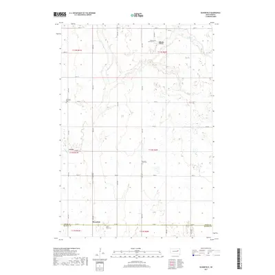
2017 Map of Bloomfield
USGS Topo · Published 2017About this map
Hillside Colony and the small settlement of Ladelle anchor this section of the South Dakota prairie, where a network of section-line roads like 407th Ave and 185th St divide the agricultural landscape. The area is defined by its deep-rooted spiritual and communal sites, including the Hillside Colony Cemetery and the Emmanuel Mennonite Cemetery. Along the southern boundary, where the line between Spink and Beadle counties runs, the Prairie Bible Church Cemetery stands near the intersection of County Road 2. The terrain is etched by the winding path of Foster Creek, which snakes through the central and northwestern sections of the quadrangle. For genealogists and local researchers, the distribution of small cemeteries like Roe Cemetery and the Missionary Church Cemetery offers a clear view of the historic settlement patterns and family enclaves in this rural heartland.
Find a feature on this map
30 named features on this map. Tap any name to fly to it.
Don’t see what you’re looking for? This feature index may not catch every label — zoom into the map to look around manually.
Map Details
Editions of this 2017 Bloomfield Map
This is the sole edition of this map. No revisions or reprints were ever made.
Other maps of this area

1895 · Byron
USGS Topo · 1:125,000

1953 · Huron
USGS Topo · 1:250,000

1953 · Watertown
USGS Topo · 1:250,000

1954 · Huron
USGS Topo · 1:250,000

1956 · Lake Byron NW
USGS Topo · 1:24,000

1956 · Lake Byron
USGS Topo · 1:24,000

1956 · Doland SW
USGS Topo · 1:24,000

1956 · Lake Byron SE
USGS Topo · 1:24,000

1958 · Watertown
USGS Topo · 1:250,000
1971 · Doland SE
USGS Topo · 1:24,000