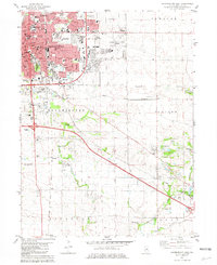
1981 Map of Bloomington East
USGS Topo · Published 1981About this map
The city of Bloomington dominates the northwest corner of this study, showcasing its development alongside Normal during the early 1980s. A dense network of medical and educational institutions, including Illinois Wesleyan University and Brokaw Hospital, anchor the urban core, while suburban expansion is visible through numerous golf courses and parks like Bloomington Country Club and Holiday Park. As the landscape transitions southeastward into Old Town and Randolph townships, the urban grid gives way to a sprawling agricultural and riparian environment defined by the winding paths of Sugar Creek and Kickapoo Creek.
Find a feature on this map
54 named features on this map. Tap any name to fly to it.
Don’t see what you’re looking for? This feature index may not catch every label — zoom into the map to look around manually.
Map Details
Editions of this 1981 Bloomington East Map
This is the sole edition of this map. No revisions or reprints were ever made.
Other maps of this area

1926 · Normal
USGS Topo · 1:62,500

1927 · Danvers
USGS Topo · 1:62,500

1930 · Danvers
USGS Topo · 1:62,500

1930 · Normal
USGS Topo · 1:62,500

1949 · Mc Lean
USGS Topo · 1:62,500

1951 · McLean
USGS Topo · 1:62,500

1951 · Le Roy
USGS Topo · 1:62,500

1958 · Peoria
USGS Topo · 1:250,000

1961 · Peoria
USGS Topo · 1:250,000

1963 · Peoria
USGS Topo · 1:250,000