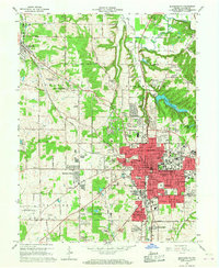
1966 Map of Bloomington
USGS Topo · Published 1967About this map
The Monon railroad corridor bisects this mid-century landscape, framing the expansion of Bloomington and its surrounding suburban and rural communities. In the northwest, Ellettsville and the small settlement of Dolan in the northeast sit amidst a terrain defined by numerous quarries, reflecting the region's enduring limestone industry. The urban core is densely marked with institutional landmarks, from the Courthouse and Federal Bldg downtown to the Indiana University Stadium and University Lake on the campus outskirts.
Find a feature on this map
94 named features on this map. Tap any name to fly to it.
Don’t see what you’re looking for? This feature index may not catch every label — zoom into the map to look around manually.
Map Details
Editions of this 1966 Bloomington Map
4 editions found
Other maps of this area

1908 · Bloomington
USGS Topo · 1:48,000

1910 · Bloomington
USGS Topo · 1:62,500

1942 · Franklin
USGS Topo · 1:125,000

1947 · Allens Creek
USGS Topo · 1:24,000

1947 · Unionville
USGS Topo · 1:24,000

1947 · Gosport
USGS Topo · 1:24,000

1948 · Hindustan
USGS Topo · 1:24,000

1950 · Gosport
USGS Topo · 1:24,000

1953 · Indianapolis
USGS Topo · 1:250,000

1956 · Indianapolis
USGS Topo · 1:250,000