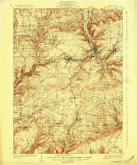
1927 Map of Blossburg
USGS Topo · Published 1927About this map
Blossburg and the surrounding coal-bearing hills of Tioga and Lycoming Counties are defined by a 1920s landscape of industrial transit and rural community. The Erie RR winds through the deep valleys, connecting the mining hub at Arnot and the village of Covington to the broader regional network. The topography is exceptionally detailed, showing the steep climbs to Huckleberry Mtn and Brier Mtn, while the high ground at Maple Hill is anchored by the Maple Hill Fire Tower. This era represents a peak for small-scale local infrastructure, evidenced by a dense distribution of country schoolhouses such as Culver School, Reed School, and Independent School. For genealogists, the map preserves the precise locations of landmarks like Blacks Mill and Hart Church, alongside small settlements like Nauvoo and Sebring that served as anchors for the local farming and timber communities before the mid-century shift toward larger consolidated townships.
Find a feature on this map
71 named features on this map. Tap any name to fly to it.
Don’t see what you’re looking for? This feature index may not catch every label — zoom into the map to look around manually.
Map Details
Editions of this 1927 Blossburg Map
4 editions found
Other maps of this area

1900 · Tioga
USGS Topo · 1:62,500

1900 · Elkland
USGS Topo · 1:62,500

1902 · Tioga
USGS Topo · 1:62,500

1921 · Trout Run
USGS Topo · 1:62,500

1923 · Trout Run
USGS Topo · 1:62,500

1925 · Blossburg
USGS Topo · 1:62,500

1927 · Blossburg
USGS Topo · 1:62,500

1930 · Warrensville
USGS Topo · 1:62,500

1931 · Troy
USGS Topo · 1:48,000

1934 · Warrensville
USGS Topo · 1:62,500