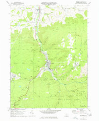
1970 Map of Blossburg
USGS Topo · Published 1977About this map
The Tioga River carves a central corridor through this section of northern Pennsylvania, where the borough of Blossburg serves as a primary hub for commerce and industry. By the early 1970s, the landscape surrounding the river valley was heavily shaped by resource extraction, evidenced by numerous Strip Mines and the Erie-Lackawanna railroad line threading through the settlements of Covington and Arnot.
Find a feature on this map
51 named features on this map. Tap any name to fly to it.
Don’t see what you’re looking for? This feature index may not catch every label — zoom into the map to look around manually.
Map Details
Editions of this 1970 Blossburg Map
4 editions found
Other maps of this area

1900 · Tioga
USGS Topo · 1:62,500

1902 · Tioga
USGS Topo · 1:62,500

1925 · Blossburg
USGS Topo · 1:62,500

1927 · Blossburg
USGS Topo · 1:62,500

1931 · Troy
USGS Topo · 1:48,000

1938 · Troy
USGS Topo · 1:62,500

1942 · Canton
USGS Topo · 1:62,500

1944 · Blossburg
USGS Topo · 1:62,500

1944 · Canton
USGS Topo · 1:62,500

1953 · Roseville
USGS Topo · 1:24,000