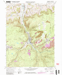
1970 Map of Blossburg
USGS Topo · Published 1986About this map
Tioga River carves a deep path through this section of the Allegheny Plateau, where the legacy of Pennsylvania’s coal industry is etched into the hillsides. The industrial footprint of Blossburg and the nearby coal patches of Morris Run and Arnot are prominently detailed, showing the extensive network of Strip Mines and Abandoned Strip Mines that define the local economy. In the northern reaches, the valley widens near Covington, while the surrounding highlands are preserved as part of the Tioga State Forest. Genealogists will find a wealth of burial sites recorded, from the central St Marys Cem and St Andrews Cem to the isolated Frost Settlement Cem. A notable geographic shift is visible in the decommissioned rail infrastructure, with several routes labeled as Abandoned, including a former Grade following Coal Run.
Find a feature on this map
59 named features on this map. Tap any name to fly to it.
Don’t see what you’re looking for? This feature index may not catch every label — zoom into the map to look around manually.
Map Details
Editions of this 1970 Blossburg Map
4 editions found
Other maps of this area

1900 · Tioga
USGS Topo · 1:62,500

1902 · Tioga
USGS Topo · 1:62,500

1925 · Blossburg
USGS Topo · 1:62,500

1927 · Blossburg
USGS Topo · 1:62,500

1931 · Troy
USGS Topo · 1:48,000

1938 · Troy
USGS Topo · 1:62,500

1942 · Canton
USGS Topo · 1:62,500

1944 · Blossburg
USGS Topo · 1:62,500

1944 · Canton
USGS Topo · 1:62,500

1953 · Roseville
USGS Topo · 1:24,000