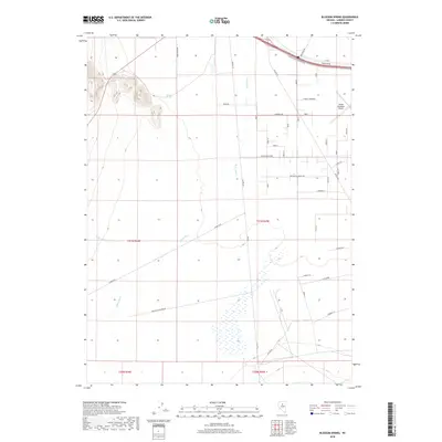
2018 Map of Blossom Spring
USGS Topo · Published 2018About this map
The Reese River meanders northward through this high desert basin, defining a landscape marked by intermittent water sources and the grid-work of rural expansion. The namesake Blossom Spring emerges near a prominent outcropping in the northwest, providing a vital anchor in an otherwise arid terrain. While much of the land remains divided by the Public Land Survey System, the northeastern corner reveals the structured growth of the region with the Battle Mountain Airport and a network of roads named after historical figures such as Thomas Jefferson and Madison. Transportation corridors like Old 8a Rd and Muleshoe Rd trace the path of local commerce and connectivity across the valley floor. Small tributaries including Little Cottonwood Cr and Lewis Cr feed into the main river channel, supporting the scattered vegetation and agricultural potential of the Lander County interior during the early 21st century.
Find a feature on this map
28 named features on this map. Tap any name to fly to it.
Don’t see what you’re looking for? This feature index may not catch every label — zoom into the map to look around manually.
Map Details
Editions of this 2018 Blossom Spring Map
This is the sole edition of this map. No revisions or reprints were ever made.
Other maps of this area

1932 · Sonoma Range
USGS Topo · 1:250,000

1939 · Sonoma Range
USGS Topo · 1:250,000

1940 · Antler Peak
USGS Topo · 1:62,500

1943 · Antler Peak
USGS Topo · 1:62,500

1949 · Mt. Lewis
USGS Topo · 1:62,500

1950 · Mt. Lewis
USGS Topo · 1:62,500

1955 · Winnemucca
USGS Topo · 1:250,000

1957 · Battle Mountain
USGS Topo · 1:62,500

1958 · Winnemucca
USGS Topo · 1:250,000

1961 · McCoy
USGS Topo · 1:62,500