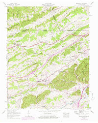
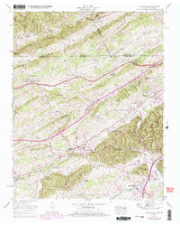
1959 Map of Blountville
USGS Topo · Published 1978About this map
Blountville serves as the focal point of this 1959 survey, situated at a major crossroads in Sullivan County where the historic Island Road and Lee Highway intersect. The landscape is defined by the rhythmic alternation of ridges and valleys typical of the Appalachian region, including the prominent Rich Valley, Dishner Valley, and the series of heights from Upper Cave Ridge down to Lower Cave Ridge. The map documents a deeply established rural community, evidenced by the numerous family-named cemeteries such as Faulkner Cem and Cox Cem that dot the hillsides.
Find a feature on this map
121 named features on this map. Tap any name to fly to it.
Don’t see what you’re looking for? This feature index may not catch every label — zoom into the map to look around manually.
Map Details
Editions of this 1959 Blountville Map
5 editions found
Other maps of this area

1891 · Roan Mountain
USGS Topo · 1:125,000

1894 · Roan Mountain
USGS Topo · 1:125,000

1897 · Bristol
USGS Topo · 1:125,000

1902 · Bristol
USGS Topo · 1:125,000

1904 · Roan Mountain
USGS Topo · 1:125,000

1934 · Wallace
USGS Topo · 1:24,000

1934 · Bristol
USGS Topo · 1:24,000

1935 · Hilton
USGS Topo · 1:24,000

1935 · Watauga Valley
USGS Topo · 1:48,000

1935 · Mendota
USGS Topo · 1:24,000