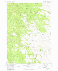
1967 Map of Blue Canyon
USGS Topo · Published 1980About this map
The ghost of a once-booming gold rush settlement is preserved here at Auburn (Site), located in the shadow of Elkhorn Ridge. During the mid-1960s, this portion of the Whitman National Forest reveals a landscape heavily shaped by hydraulic mining and water management, evidenced by the Elk Creek Settling Tank and the remnants of the Old Auburn Res. The map provides a detailed look at the water systems required for these operations, tracing Littlefield Ditch as it winds through canyons like Freezeout Canyon and past several springs. To the west, the Powder River feeds into Phillips Lake, where a Gaging Station monitors the flow. Family history and small-scale habitation are marked by the Cem near the old townsite and the Malloy Cabin (Ruin) at the northern edge of the survey, offering a glimpse into the rugged lives of early Oregon miners and settlers.
Find a feature on this map
42 named features on this map. Tap any name to fly to it.
Don’t see what you’re looking for? This feature index may not catch every label — zoom into the map to look around manually.
Map Details
Editions of this 1967 Blue Canyon Map
3 editions found
Other maps of this area

1901 · Baker City
USGS Topo · 1:125,000

1901 · Sumpter
USGS Topo · 1:125,000

1955 · Baker
USGS Topo · 1:250,000

1955 · Canyon City
USGS Topo · 1:250,000

1959 · Baker
USGS Topo · 1:250,000

1959 · Canyon City
USGS Topo · 1:250,000

1967 · Baker
USGS Topo · 1:24,000

1967 · Dooley Mtn
USGS Topo · 1:24,000

1967 · Blue Canyon
USGS Topo · 1:24,000
1967 · Bowen Valley
USGS Topo · 1:24,000