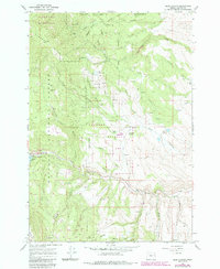
1967 Map of Blue Canyon
USGS Topo · Published 1985About this map
Auburn sits as a remnant of former settlement within the high reaches of the Whitman National Forest, reflecting the area's transition from a mining and timber hub to a managed wilderness. Traces of human presence remain visible through the Cem and the Malloy Cabin, while the landscape is defined by the steep descent of the Elkhorn Ridge. This 1967 survey, with updates from the early 1980s, highlights the essential water management systems of the region, including the Baker City Watershed and several reservoirs like Old Auburn Res. The southern edge of the map follows the winding path of the Powder River, which feeds into the eastern reaches of Phillips Lake. This intersection of conservation and utility is further evidenced by the Elkhorn Wildlife Area and its Elkhorn Feeding Station, established to support local fauna amidst the gulches and peaks.
Find a feature on this map
41 named features on this map. Tap any name to fly to it.
Don’t see what you’re looking for? This feature index may not catch every label — zoom into the map to look around manually.
Map Details
Editions of this 1967 Blue Canyon Map
3 editions found
Other maps of this area

1901 · Baker City
USGS Topo · 1:125,000

1901 · Sumpter
USGS Topo · 1:125,000

1955 · Baker
USGS Topo · 1:250,000

1955 · Canyon City
USGS Topo · 1:250,000

1959 · Baker
USGS Topo · 1:250,000

1959 · Canyon City
USGS Topo · 1:250,000

1967 · Baker
USGS Topo · 1:24,000

1967 · Dooley Mtn
USGS Topo · 1:24,000

1967 · Blue Canyon
USGS Topo · 1:24,000
1967 · Bowen Valley
USGS Topo · 1:24,000