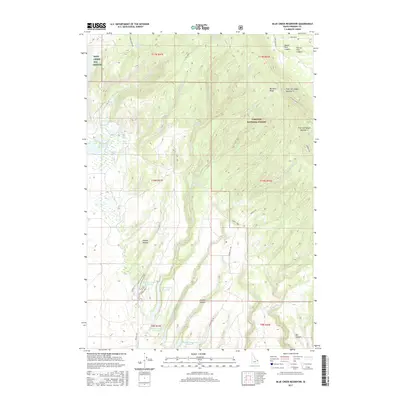
2017 Map of Blue Creek Reservoir
USGS Topo · Published 2017About this map
Sand Creek Elk Refuge and the Targhee National Forest converge in this high-altitude landscape of the Idaho backcountry. The terrain is defined by the massive geologic signatures of the Island Park Caldera and the Henrys Fork Caldera, creating a complex network of ridges like Big Bend Ridge and deep incisions such as Box Canyon. Water management is central to this geography, evidenced by a series of impoundments including Blue Creek Reservoir, Sand Creek Reservoir, and the Upper Arcadia Reservoir. Numerous natural springs, such as Sharp Springs, Jackson Mill Spring, and Bear Wallow Spring, feed the local drainages of Blue Cr and July Creek. This 2017 survey details the remote roads and trails, such as Sadorus Hill Rd and Free Use Canyon, that provide access to this volcanic upland.
Find a feature on this map
50 named features on this map. Tap any name to fly to it.
Don’t see what you’re looking for? This feature index may not catch every label — zoom into the map to look around manually.
Map Details
Editions of this 2017 Blue Creek Reservoir Map
This is the sole edition of this map. No revisions or reprints were ever made.
Other maps of this area

1955 · Ashton
USGS Topo · 1:250,000

1958 · Ashton
USGS Topo · 1:250,000

1960 · Ashton
USGS Topo · 1:250,000

1964 · Last Chance
USGS Topo · 1:24,000
1965 · Black Knoll
USGS Topo · 1:24,000

1965 · Lemon Lake
USGS Topo · 1:24,000
1965 · Split Butte
USGS Topo · 1:24,000

1965 · Ashton
USGS Topo · 1:24,000

1965 · Lookout Butte
USGS Topo · 1:24,000

1965 · Blue Creek Reservoir
USGS Topo · 1:24,000