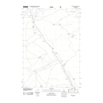
2011 Map of Blue Dome
USGS Topo · Published 2011About this map
Birch Creek flows southeast through a valley defined by deep canyons and gulches in this 2011 survey of Butte County. The landscape is marked by small settlements and resource management sites, including Blue Dome, Lone Pine, and the Birch Creek Hatchery in the north. The drainage patterns of the Lemhi Range are clearly delineated, showing where Pass Creek and its forks meet the valley floor. To the south, the John Day Cemetery provides a specific point of interest for genealogists and local historians. Steep terrain features like Skull Canyon, Kaufman Gulch, and Bald Mountain Gulch dominate the topography, while a network of forest roads like Pass Creek Rd and Skull Canyon Rd provides access to the higher elevations and remote canyons.
Find a feature on this map
31 named features on this map. Tap any name to fly to it.
Don’t see what you’re looking for? This feature index may not catch every label — zoom into the map to look around manually.
Map Details
Editions of this 2011 Blue Dome Map
This is the sole edition of this map. No revisions or reprints were ever made.
Other maps of this area

1955 · Dubois
USGS Topo · 1:250,000

1956 · Nicholia
USGS Topo · 1:62,500

1957 · Diamond Peak
USGS Topo · 1:62,500

1957 · Scott Peak
USGS Topo · 1:62,500

1958 · Dubois
USGS Topo · 1:250,000

1969 · Eightmile Canyon
USGS Topo · 1:24,000

1969 · Copper Mtn
USGS Topo · 1:24,000
1969 · Blue Dome
USGS Topo · 1:24,000
1969 · Scott Butte
USGS Topo · 1:24,000

1983 · Dubois
USGS Topo · 1:100,000