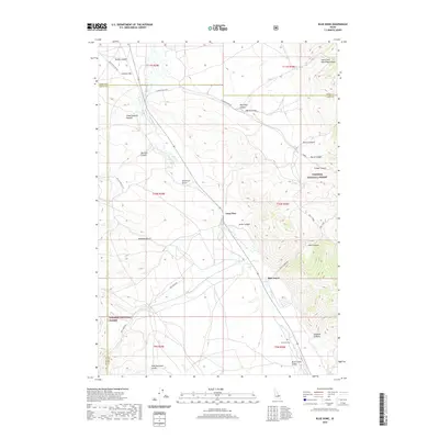
2020 Map of Blue Dome
USGS Topo · Published 2020About this map
Birch Cr flows through a landscape defined by deep gulches and steep canyon walls at the junction of Butte, Lemhi, and Clark counties. Small outposts like Blue Dome and Lone Pine are situated along the valley floor, serving as points of reference in a territory dominated by the Targhee National Forest. The geography is shaped by drainage patterns from Worthing Canyon, Sawmill Canyon, and Skull Canyon, all feeding into the broader Birch Creek Valley. Evidence of earlier resource extraction persists at the Skull Mine near Skull Canyon Rd, while the John Day Cem near the southern boundary provides a rare genealogical marker for the area's residents. The road network, including Pass Creek Rd and O Brien Gulch Rd, follows the natural contours of the terrain, connecting remote sites like Johnson Bar to the primary valley thoroughfares.
Find a feature on this map
39 named features on this map. Tap any name to fly to it.
Don’t see what you’re looking for? This feature index may not catch every label — zoom into the map to look around manually.
Map Details
Editions of this 2020 Blue Dome Map
This is the sole edition of this map. No revisions or reprints were ever made.
Other maps of this area

1955 · Dubois
USGS Topo · 1:250,000

1956 · Nicholia
USGS Topo · 1:62,500

1957 · Diamond Peak
USGS Topo · 1:62,500

1957 · Scott Peak
USGS Topo · 1:62,500

1958 · Dubois
USGS Topo · 1:250,000

1969 · Eightmile Canyon
USGS Topo · 1:24,000

1969 · Copper Mtn
USGS Topo · 1:24,000
1969 · Blue Dome
USGS Topo · 1:24,000
1969 · Scott Butte
USGS Topo · 1:24,000

1983 · Dubois
USGS Topo · 1:100,000