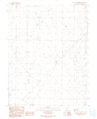
1990 Map of Blue Eagle Springs NE
USGS Topo · Published 1990About this map
Munson sits at the intersection of water and industry on this 1990 provisional survey of Nye County. The landscape is defined by the drainage patterns of Duckwater Creek and Currant Creek, which traverse an arid environment marked by Alkali Flat. Human activity here centers on resource extraction and water management, evidenced by numerous Oil Wells, industrial Tanks, and Gravel Pits scattered near the basin floors. The reliance on subterranean water sources is clear, with features like Flowing Well and the specifically noted Gravel Ridge Well (Flowing) serving as vital points in the desert. Numerous Drill Holes throughout the quadrangle suggest a period of active exploration or geological testing during the late twentieth century, while The Big Wash provides a natural landmark within the basin's eastern drainage.
Find a feature on this map
29 named features on this map. Tap any name to fly to it.
Don’t see what you’re looking for? This feature index may not catch every label — zoom into the map to look around manually.
Map Details
Editions of this 1990 Blue Eagle Springs NE Map
This is the sole edition of this map. No revisions or reprints were ever made.
Other maps of this area

1956 · Lund
USGS Topo · 1:250,000

1957 · Currant Mtn
USGS Topo · 1:62,500

1960 · Lund
USGS Topo · 1:250,000

1964 · Blue Eagle Springs
USGS Topo · 1:62,500

1964 · Duckwater
USGS Topo · 1:62,500

1964 · Currant
USGS Topo · 1:62,500

1964 · Currant Mtn
USGS Topo · 1:62,500

1980 · Duckwater
USGS Topo · 1:100,000
1990 · Bradshaw Spring
USGS Topo · 1:24,000
1990 · Currant
USGS Topo · 1:24,000