
1956 Map of Blue Hill
USGS Topo · Published 1958About this map
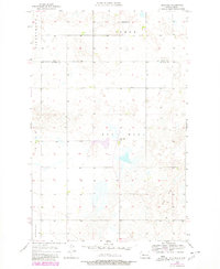
Blue Hill rises above the prairie landscape of central North Dakota, serving as the namesake for this 1950s study by the Water Conservation Commission. The terrain is characterized by numerous small depressions and potholes typical of the glaciated plains, with the ephemeral Hiddenwood watercourse tracing through the northwest. Small-scale rural infrastructure is the primary marker of human activity, represented by isolated landmarks like the Well in the southeast. Education in this agrarian region remained decentralized at the time of this survey, anchored by local institutions such as Blue Hill Sch and Centerville Sch. The map records the boundary where Ward and McLean counties meet, capturing the area as a network of section lines and unimproved roads connecting disparate farmsteads before the modern consolidation of rural districts.
Find a feature on this map
8 named features on this map. Tap any name to fly to it.
Don’t see what you’re looking for? This feature index may not catch every label — zoom into the map to look around manually.
Map Details
Editions of this 1956 Blue Hill Map
2 editions found
Other maps of this area

1954 · McClusky
USGS Topo · 1:250,000

1956 · Emmet NE
USGS Topo · 1:24,000

1956 · Blackwater Lake
USGS Topo · 1:24,000

1956 · Emmet
USGS Topo · 1:24,000

1956 · Douglas West
USGS Topo · 1:24,000

1956 · Roseglen
USGS Topo · 1:24,000

1958 · McClusky
USGS Topo · 1:250,000

1980 · Lake Vernon
USGS Topo · 1:24,000

1980 · Makoti
USGS Topo · 1:24,000
1981 · Ryder
USGS Topo · 1:24,000