
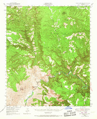
1946 Map of Blue House Mtn
USGS Topo · Published 1956About this map
The Salt River carves a deep path through the heart of this mid-century Arizona landscape, serving as a natural boundary between major land designations. To the north lies the Fort Apache Indian Reservation, while the southern reaches are shared by the Tonto National Forest and the San Carlos Indian Reservation. The map reveals a high concentration of mineral exploration along the river's canyon walls, including the Apache Mine, Regal Mine, and Canadian Mines. Beyond industrial extraction, the presence of the Samrace Cliff Dwellings and an additional Cliff Dwelling near the river indicates the long-term human history of this complex terrain. Notable landmarks like Blue House Mtn and Mule Hoof Bend provide orientation within this network of deep canyons and ridges, such as Keystone Ridge and Mustang Ridge.
Find a feature on this map
51 named features on this map. Tap any name to fly to it.
Don’t see what you’re looking for? This feature index may not catch every label — zoom into the map to look around manually.
Map Details
Editions of this 1946 Blue House Mtn Map
2 editions found
Other maps of this area

1886 · Holbrook
USGS Topo · 1:250,000

1893 · Holbrook
USGS Topo · 1:250,000

1922 · Chrysotile
USGS Topo · 1:125,000

1949 · McFadden Peak
USGS Topo · 1:62,500

1949 · Rockinstraw Mtn
USGS Topo · 1:62,500

1950 · Rockinstraw Mtn
USGS Topo · 1:62,500

1950 · McFadden Peak
USGS Topo · 1:62,500

1951 · Blue House Mtn
USGS Topo · 1:62,500

1954 · Holbrook
USGS Topo · 1:250,000

1954 · Mesa
USGS Topo · 1:250,000