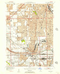
1953 Map of Blue Island
USGS Topo · Published 1956About this map
Blue Island serves as a major industrial and transit hub in the early 1950s, defined by the convergence of the Rock Island RR, Pennsylvania RR, and Grand Trunk Western RR. The landscape is a dense mixture of burgeoning suburban residential tracts and massive institutional footprints, particularly the numerous large cemeteries like St Casimirs Cemetery and Mt Olivet Cemetery that separate Mount Greenwood from Blue Island.
Find a feature on this map
103 named features on this map. Tap any name to fly to it.
Don’t see what you’re looking for? This feature index may not catch every label — zoom into the map to look around manually.
Map Details
Editions of this 1953 Blue Island Map
This is the sole edition of this map. No revisions or reprints were ever made.
Other maps of this area

1889 · Chicago
USGS Topo · 1:62,500

1890 · Des Plaines
USGS Topo · 1:62,500

1891 · Chicago
USGS Topo · 1:62,500

1891 · Riverside
USGS Topo · 1:62,500

1892 · Calumet
USGS Topo · 1:62,500

1893 · Calumet
USGS Topo · 1:62,500

1893 · Riverside
USGS Topo · 1:62,500

1894 · Des Plaines
USGS Topo · 1:62,500

1900 · Chicago
USGS Topo · 1:62,500

1900 · Des Plaines
USGS Topo · 1:62,500