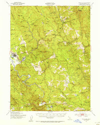
1951 Map of Blue Lake
USGS Topo · Published 1955About this map
The Mad River and its North Fork define this mid-century landscape of timber, ranching, and high-altitude prairies. Settlement centers around the logging community of Korbel and the neighboring city of Blue Lake, where the Mad River bends sharply near several small gulches. In the more remote interior of the Six Rivers National Forest, the map records a sparse network of family-held properties like Angel Ranch, Butler Valley Ranch, and Ayres Cabin, interspersed with numerous named prairies such as High Prairie and Heustis Prairie.
Find a feature on this map
76 named features on this map. Tap any name to fly to it.
Don’t see what you’re looking for? This feature index may not catch every label — zoom into the map to look around manually.
Map Details
Editions of this 1951 Blue Lake Map
5 editions found

Other maps of this area

1914 · Pilot Creek
USGS Topo · 1:62,500

1915 · Big Bar and Vicinity
USGS Topo · 1:250,000

1922 · Eureka
USGS Topo · 1:62,500

1922 · Korbel
USGS Topo · 1:62,500

1922 · China Flat
USGS Topo · 1:62,500

1922 · Kneeland
USGS Topo · 1:62,500

1925 · Hoopa
USGS Topo · 1:125,000

1933 · Eureka
USGS Topo · 1:48,000

1942 · Eureka
USGS Topo · 1:62,500

1944 · Fortuna
USGS Topo · 1:62,500