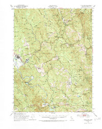
1951 Map of Blue Lake
USGS Topo · Published 1984About this map
Blue Lake and the industrial hub at Korbel anchor the western edge of this mid-century survey, where the Arcata and Mad River Railroad winds along the Mad River. The landscape is defined by the transition from river valley to the steep ridgelines of the Six Rivers National Forest, including the prominent Wiregrass Ridge and Liptop Ridge. This 1951 culture revision reveals a rural economy organized around isolated family holdings and ranching outposts such as Butler Valley Ranch, Angel Ranch, and Redwood Creek Ranch.
Find a feature on this map
85 named features on this map. Tap any name to fly to it.
Don’t see what you’re looking for? This feature index may not catch every label — zoom into the map to look around manually.
Map Details
Editions of this 1951 Blue Lake Map
5 editions found

Other maps of this area

1914 · Pilot Creek
USGS Topo · 1:62,500

1915 · Big Bar and Vicinity
USGS Topo · 1:250,000

1922 · Eureka
USGS Topo · 1:62,500

1922 · Korbel
USGS Topo · 1:62,500

1922 · China Flat
USGS Topo · 1:62,500

1922 · Kneeland
USGS Topo · 1:62,500

1925 · Hoopa
USGS Topo · 1:125,000

1933 · Eureka
USGS Topo · 1:48,000

1942 · Eureka
USGS Topo · 1:62,500

1944 · Fortuna
USGS Topo · 1:62,500