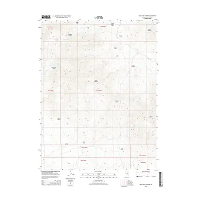
2014 Map of Blue Mass Canyon
USGS Topo · Published 2014About this map
Kern Mountains dominate this high-elevation corner of White Pine County, where a network of springs and canyons dictates the movement of both water and travelers. The presence of Blue Mass Spring, Rock Springs, and Mike Springs provides critical water points in an otherwise arid landscape, while Moffet Pass offers a transit point through the high ridges. The map reveals the intricate drainage patterns feeding into Tungstonia Wash and Gravel Wash, illustrating how the terrain channels seasonal runoff from the surrounding peaks.
Find a feature on this map
34 named features on this map. Tap any name to fly to it.
Don’t see what you’re looking for? This feature index may not catch every label — zoom into the map to look around manually.
Map Details
Editions of this 2014 Blue Mass Canyon Map
This is the sole edition of this map. No revisions or reprints were ever made.
Other maps of this area

1956 · Ely
USGS Topo · 1:250,000

1959 · Ely
USGS Topo · 1:250,000

1963 · Ely
USGS Topo · 1:250,000
1981 · Tippett Canyon
USGS Topo · 1:24,000
1981 · Weaver Canyon
USGS Topo · 1:24,000
1986 · Grass Valley Wash
USGS Topo · 1:24,000
1986 · White Cloud Point
USGS Topo · 1:24,000
1986 · Government Peak
USGS Topo · 1:24,000
1986 · Tippett
USGS Topo · 1:24,000
1986 · Tin Springs Mountain
USGS Topo · 1:24,000