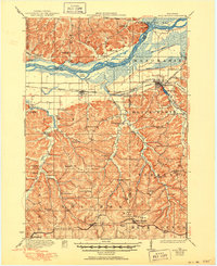
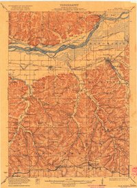
1922 Map of Blue Mounds
USGS Topo · Published 1950About this map
Wisconsin River currents dominate the northern edge of this 1920s-era landscape, where the braided channel winds past Cedar Island and the prominent Ferry Bluff. The region reflects a dense network of early 20th-century rural life, evidenced by the high concentration of neighborhood schoolhouses like Pikes Peak School, Sandridge School, and Mounds Creek School. The rugged terrain of Blue Mounds and Black Earth is segmented by deep hollows and narrow valleys, such as Ray Hollow and Knight Valley, which dictated the early road and rail patterns.
Find a feature on this map
82 named features on this map. Tap any name to fly to it.
Don’t see what you’re looking for? This feature index may not catch every label — zoom into the map to look around manually.
Map Details
Editions of this 1922 Blue Mounds Map
3 editions found
Other maps of this area

1895 · Baraboo
USGS Topo · 1:62,500

1901 · Denzer
USGS Topo · 1:62,500

1902 · Mineral Point
USGS Topo · 1:125,000

1905 · Richland Center
USGS Topo · 1:125,000

1907 · Cross Plains
USGS Topo · 1:62,500

1908 · Baraboo
USGS Topo · 1:62,500

1909 · Cross Plains
USGS Topo · 1:62,500

1920 · Blue Mounds
USGS Topo · 1:62,500

1922 · Blue Mounds
USGS Topo · 1:62,500

1923 · Blanchardville
USGS Topo · 1:62,500