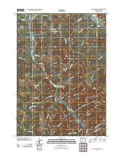
2011 Map of Blue Mountain
USGS Topo · Published 2011About this map
Mosby Creek carves a central path through this section of the Oregon Cascades foothills, defining the drainage patterns and transportation routes of the region. The landscape is heavily marked by the timber industry and local infrastructure, notably the Booth-Kelly Lumber Company Log Pond situated along the creek south of Abrams. This map reflects a working forest environment where corporate and public interests meet, shown through roads like Weyerhauser Rd and various BLM Rd routes. To the north, the Row River flows into the Dorena Reservoir, crossed by the Dorena Bridge. Local history is anchored by the Broumbaugh Cemetery in the northwest and landmarks like Blue Mountain and Blue Rock. The inclusion of Blue Mountain School Rd points to the area's educational and social foundations established for early logging and farming families.
Find a feature on this map
53 named features on this map. Tap any name to fly to it.
Don’t see what you’re looking for? This feature index may not catch every label — zoom into the map to look around manually.
Map Details
Editions of this 2011 Blue Mountain Map
This is the sole edition of this map. No revisions or reprints were ever made.
Other maps of this area

1921 · Cottage Grove
USGS Topo · 1:62,500

1935 · Lowell
USGS Topo · 1:96,000

1942 · Lowell
USGS Topo · 1:125,000

1954 · Anlauf
USGS Topo · 1:62,500

1955 · Culp Creek
USGS Topo · 1:62,500

1955 · Lowell
USGS Topo · 1:62,500
1957 · Cottage Grove
USGS Topo · 1:62,500

1958 · Roseburg
USGS Topo · 1:250,000

1959 · Roseburg
USGS Topo · 1:250,000

1979 · Cottage Grove
USGS Topo · 1:100,000