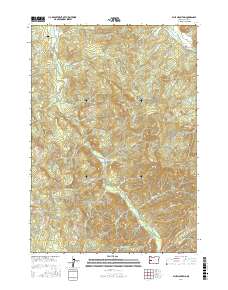
2017 Map of Blue Mountain
USGS Topo · Published 2017About this map
Mosby Creek winds through this timber-heavy corridor of Lane County, reflecting a landscape defined by the intersection of industrial forestry and rural homesteads. The presence of the Booth-Kelly Lumber Company Log Pond and Weyerhauser Rd underscores the long-standing role of the timber industry in this region. Genealogists and local historians can locate the Broumbaugh Cem in the northwest, along with the legacy of rural education preserved in the name of Blue Mountain School Rd. The map also captures significant physical landmarks including Blue Mountain, Blue Rock, and Round Mtn, which dominate the central and eastern portions of the quadrangle. Transport and access are dictated by the creek valleys, with Row River Rd and the Dorena Bridge serving as vital links near the northern boundary.
Find a feature on this map
56 named features on this map. Tap any name to fly to it.
Don’t see what you’re looking for? This feature index may not catch every label — zoom into the map to look around manually.
Map Details
Editions of this 2017 Blue Mountain Map
This is the sole edition of this map. No revisions or reprints were ever made.
Other maps of this area

1921 · Cottage Grove
USGS Topo · 1:62,500

1935 · Lowell
USGS Topo · 1:96,000

1942 · Lowell
USGS Topo · 1:125,000

1954 · Anlauf
USGS Topo · 1:62,500

1955 · Culp Creek
USGS Topo · 1:62,500

1955 · Lowell
USGS Topo · 1:62,500
1957 · Cottage Grove
USGS Topo · 1:62,500

1958 · Roseburg
USGS Topo · 1:250,000

1959 · Roseburg
USGS Topo · 1:250,000

1979 · Cottage Grove
USGS Topo · 1:100,000