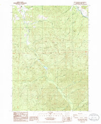
1986 Map of Blue Mountain
USGS Topo · Published 1986About this map
Mosby Creek and its many tributaries, including Simpson Creek and Palmer Creek, dominate this mountainous portion of Lane County during the mid-1980s. The landscape is defined by its industrial activity and local landmarks, notably the numerous quarries scattered throughout the timbered slopes. In the northeastern corner, the Row River flows through a narrow corridor, marked by the Dorena Bridge (Covered) and the waters of Dorena Lake. Small settlements like Abrams and Perkins are situated along the creek beds, providing a window into the rural life of the western Cascades during this era.
Find a feature on this map
38 named features on this map. Tap any name to fly to it.
Don’t see what you’re looking for? This feature index may not catch every label — zoom into the map to look around manually.
Map Details
Editions of this 1986 Blue Mountain Map
This is the sole edition of this map. No revisions or reprints were ever made.
Other maps of this area

1921 · Cottage Grove
USGS Topo · 1:62,500

1935 · Lowell
USGS Topo · 1:96,000

1942 · Lowell
USGS Topo · 1:125,000

1954 · Anlauf
USGS Topo · 1:62,500

1955 · Culp Creek
USGS Topo · 1:62,500

1955 · Lowell
USGS Topo · 1:62,500
1957 · Cottage Grove
USGS Topo · 1:62,500

1958 · Roseburg
USGS Topo · 1:250,000

1959 · Roseburg
USGS Topo · 1:250,000

1979 · Cottage Grove
USGS Topo · 1:100,000