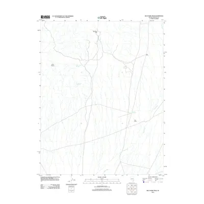
2012 Map of Blue Nose Peak
USGS Topo · Published 2012About this map
Blue Nose Peak overlooks a landscape defined by seasonal water management and desert expanse in this early 21st-century survey of Lincoln County. The environment is marked by numerous ephemeral drainages, including the expansive Garden Wash and Sams Camp Wash, which flow toward the Tule Desert. Human presence in this arid region is tied to small-scale water infrastructure and temporary camps, evidenced by the Dodge Pocket Reservoir and White Rock Reservoir. These water sources, along with features like the End of the Line Trough and the depression known as Dodge Pockets, indicate the area's importance for cattle ranching or land management in the High Desert. The isolated location of Wests Camp further emphasizes the remote, utilitarian nature of the settlements scattered across this portion of Nevada.
Find a feature on this map
9 named features on this map. Tap any name to fly to it.
Don’t see what you’re looking for? This feature index may not catch every label — zoom into the map to look around manually.
Map Details
Editions of this 2012 Blue Nose Peak Map
This is the sole edition of this map. No revisions or reprints were ever made.
Other maps of this area

1885 · Pioche
USGS Topo · 1:250,000

1886 · Pioche
USGS Topo · 1:250,000

1954 · Caliente
USGS Topo · 1:250,000

1959 · Caliente
USGS Topo · 1:250,000
1973 · Leith
USGS Topo · 1:24,000
1973 · Jacks Mountain
USGS Topo · 1:24,000
1973 · Tule Spring
USGS Topo · 1:24,000
1973 · Lime Mountain
USGS Topo · 1:24,000
1973 · Toquop Gap
USGS Topo · 1:24,000
1973 · Blue Nose Peak
USGS Topo · 1:24,000