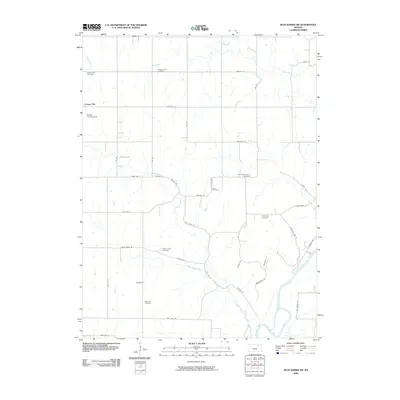
2009 Map of Blue Rapids SW
USGS Topo · Published 2009About this map
Cottage Hill serves as the primary community anchor in this rural portion of Marshall County, situated among a network of cemeteries that speak to the area's diverse ethnic and cultural settlement history. The landscape is defined by the drainage patterns of the Big Blue River and its numerous tributaries, including Swede Creek, Little Swede Creek, and Game Fork. This 2009 survey reveals the lasting presence of immigrant communities through landmarks like the Saint Wenceslaus Cemetery and Czech Cemetery, which sit along the grid of gravel roads. The terrain is largely agricultural, punctuated by small-scale developments such as the Roepke Landing Strip and a series of family and community burial grounds, including Pleasant Hill Cemetery and Rose Hill Cemetery. The interplay of names like Bellegarde Cemetery and Swede Creek Cemetery illustrates the localized heritage of the families who worked these prairie lands.
Find a feature on this map
48 named features on this map. Tap any name to fly to it.
Don’t see what you’re looking for? This feature index may not catch every label — zoom into the map to look around manually.
Map Details
Editions of this 2009 Blue Rapids SW Map
This is the sole edition of this map. No revisions or reprints were ever made.
Other maps of this area

1886 · Junction City
USGS Topo · 1:125,000

1889 · Marysville
USGS Topo · 1:125,000

1889 · Junction City
USGS Topo · 1:125,000

1894 · Junction City
USGS Topo · 1:125,000

1894 · Marysville
USGS Topo · 1:125,000

1955 · Manhattan
USGS Topo · 1:250,000

1956 · Manhattan
USGS Topo · 1:250,000

1957 · Manhattan
USGS Topo · 1:250,000
1964 · Randolph
USGS Topo · 1:24,000
1964 · Olsburg
USGS Topo · 1:24,000