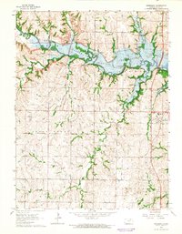
1964 Map of Randolph
USGS Topo · Published 1965About this map
Tuttle Creek Reservoir dominates the northern half of this Riley County landscape, its irregular shoreline reaching deep into the drainage basins of Fancy Creek and Otter Creek. The creation of this reservoir significantly altered the local geography, inundating valleys and creating a new aquatic boundary between the townships of Center, Jackson, and Fancy Creek. The small community of Randolph sits on the eastern edge of the water, serves as a focal point for the region, and is home to the Blue Valley High Sch. To the west and south, the terrain remains characterized by traditional Kansas agricultural patterns, with dispersed settlements like Winkler and Walsburg connected by a network of rural roads. Genealogists will find several burial sites preserved across the hills, including St Johns Cem, Crooked Creek Cem, and Leonardville Cem.
Find a feature on this map
23 named features on this map. Tap any name to fly to it.
Don’t see what you’re looking for? This feature index may not catch every label — zoom into the map to look around manually.
Map Details
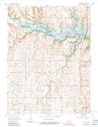
Editions of this 1964 Randolph Map
2 editions found
Other maps of this area

1886 · Junction City
USGS Topo · 1:125,000

1889 · Marysville
USGS Topo · 1:125,000

1889 · Junction City
USGS Topo · 1:125,000

1894 · Junction City
USGS Topo · 1:125,000

1894 · Marysville
USGS Topo · 1:125,000

1955 · Manhattan
USGS Topo · 1:250,000

1956 · Manhattan
USGS Topo · 1:250,000

1957 · Manhattan
USGS Topo · 1:250,000
1963 · Bala
USGS Topo · 1:24,000
1963 · Lasita
USGS Topo · 1:24,000