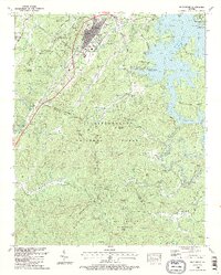
1988 Map of Blue Ridge
USGS Topo · Published 1988About this map
The mountain town of Blue Ridge and the nearby settlement of Morganton serve as the primary hubs in this late 1980s topographic portrait of Fannin County. The landscape is defined by the massive waters of Blue Ridge Lake and the meandering path of the Toccoa River, which flows through the Free Bend and beneath the Shallow Ford Bridge. Cultural and community anchors are prominent, including the Blue Ridge School, City Hall, and several local congregations such as New Antioch Church and Olive Church.
Find a feature on this map
86 named features on this map. Tap any name to fly to it.
Don’t see what you’re looking for? This feature index may not catch every label — zoom into the map to look around manually.
Map Details
Editions of this 1988 Blue Ridge Map
2 editions found
Other maps of this area

1888 · Ellijay
USGS Topo · 1:125,000

1892 · Ellijay
USGS Topo · 1:125,000

1898 · Ellijay
USGS Topo · 1:125,000

1911 · Ellijay
USGS Topo · 1:125,000

1935 · Epworth
USGS Topo · 1:24,000

1935 · Noontootla
USGS Topo · 1:24,000

1935 · Mineral Bluff
USGS Topo · 1:24,000
1935 · Cashes Valley
USGS Topo · 1:24,000

1935 · Lake Toccoa
USGS Topo · 1:24,000

1935 · Tickanetley
USGS Topo · 1:24,000