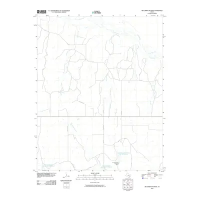
2010 Map of Blue Ridge School
USGS Topo · Published 2010About this map
The Canadian River flows across the northern reaches of this Hemphill County landscape, marking the high plains of the Texas Panhandle. This 2010 survey highlights a sophisticated network of water management and rural infrastructure, centered on the Soil Conservation Service Site 15a Dam and its associated Soil Conservation Service Site 15a Reservoir. The terrain is defined by the drainage patterns of numerous tributaries, including Needmore Creek, Turkey Creek, and Cabin Creek, which carve through the plains toward the main river channel. To the south, the headwaters of the Dry Fork Washita River begin their descent, accompanied by further conservation sites like Soil Conservation Service Site 13 Reservoir. Local naming conventions are preserved through rural road designations such as Walter Eubanks and Thomas Slavin, reflecting the long-standing ranching and land-use history of the region.
Find a feature on this map
19 named features on this map. Tap any name to fly to it.
Don’t see what you’re looking for? This feature index may not catch every label — zoom into the map to look around manually.
Map Details
Editions of this 2010 Blue Ridge School Map
This is the sole edition of this map. No revisions or reprints were ever made.
Other maps of this area

1954 · Amarillo
USGS Topo · 1:250,000

1958 · Amarillo
USGS Topo · 1:250,000

1967 · Dads Creek
USGS Topo · 1:24,000

1967 · Gem
USGS Topo · 1:24,000

1967 · Hackberry Creek
USGS Topo · 1:24,000

1967 · Lake June
USGS Topo · 1:24,000

1967 · Blue Ridge School
USGS Topo · 1:24,000

1967 · Canadian SE
USGS Topo · 1:24,000

1972 · Canadian East
USGS Topo · 1:24,000
1972 · Lake Marvin
USGS Topo · 1:24,000