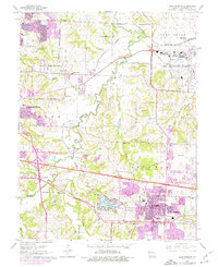
1965 Map of Blue Springs
USGS Topo · Published 1976About this map
The Little Blue River and its winding tributaries, including Spring Branch and Burr Oak Creek, define the landscape between Independence and Blue Springs during this mid-century period. Industrial and military footprints are prominent, most notably the sprawling Lake City Army Ammunition Plant in the northeast and the Missouri Pacific rail corridor. The map captures the suburban expansion of East Independence, where residential growth begins to encroach on older landmarks like the Spring Branch Sch and Trinity Ch. Purple revisions highlight the rapid urban extension occurring by the early 1970s. For genealogists and local historians, the sheet preserves the locations of several community hubs, from the Lobb Cumberland Ch and its adjacent Lobb Cem to the early airfield at Independence Memorial Airport and the recreational waters of Lake Tapawingo.
Find a feature on this map
54 named features on this map. Tap any name to fly to it.
Don’t see what you’re looking for? This feature index may not catch every label — zoom into the map to look around manually.
Map Details
Editions of this 1965 Blue Springs Map
3 editions found
Other maps of this area

1887 · Harrisonville
USGS Topo · 1:125,000

1892 · Harrisonville
USGS Topo · 1:125,000

1894 · Harrisonville
USGS Topo · 1:125,000

1894 · Independence
USGS Topo · 1:125,000

1933 · Blue Springs
USGS Topo · 1:24,000

1934 · Oak Grove
USGS Topo · 1:24,000

1934 · Independence
USGS Topo · 1:24,000

1934 · Lees Summit
USGS Topo · 1:24,000

1934 · Woods Chapel
USGS Topo · 1:24,000

1935 · Buckner
USGS Topo · 1:24,000