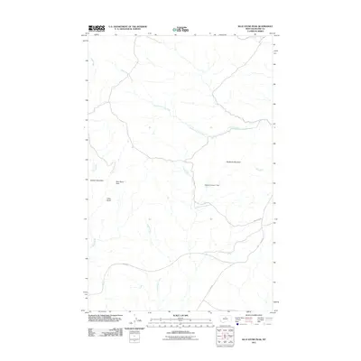
2011 Map of Blue Stone Peak
USGS Topo · Published 2011About this map
Blue Stone Peak and the surrounding high country of Blaine County define this landscape at the edge of the Bears Paw Mountains. The terrain is marked by prominent elevations including Elkhorn Mountain and the jagged profile of Sawtooth Mountain. Drainage systems are deeply etched into the topography, with South Fork Cow Creek and Sand Creek flowing through the northern and western reaches, while Volcano Creek cuts through the central region. Human infrastructure is sparse, concentrated primarily along a few established corridors like Warrick Rd and Lloyd Rd. The presence of the Moore Number 1 Dam indicates the vital importance of water management in this arid environment, providing a localized point of interest for researchers tracing the development of ranching and land use in this part of Montana during the early 21st century.
Find a feature on this map
12 named features on this map. Tap any name to fly to it.
Don’t see what you’re looking for? This feature index may not catch every label — zoom into the map to look around manually.
Map Details
Editions of this 2011 Blue Stone Peak Map
This is the sole edition of this map. No revisions or reprints were ever made.
Other maps of this area

1953 · Havre
USGS Topo · 1:250,000

1954 · Lewistown
USGS Topo · 1:250,000

1956 · Maddux
USGS Topo · 1:62,500

1957 · Havre
USGS Topo · 1:250,000

1958 · Havre
USGS Topo · 1:250,000

1959 · Lewistown
USGS Topo · 1:250,000

1959 · Warrick
USGS Topo · 1:62,500
1984 · Eskay NE
USGS Topo · 1:24,000

1984 · Big John Butte
USGS Topo · 1:24,000
1984 · Warrick
USGS Topo · 1:24,000