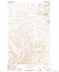
1984 Map of Eskay NE
USGS Topo · Published 1984About this map
Blue Stone Peak and Tiger Butte dominate the northern landscape of this North Central Montana terrain, where the boundary between Chouteau County and Blaine County cuts through a high-plains environment. The drainage network is defined by Sand Creek and its tributaries, including Little Sand Creek and West Fork Sand Creek, which carve through the land alongside features like Pigtail Coulee. This 1984 survey, based on 1978 field checks, captures a sparsely populated region of the state where prominent elevations served as essential landmarks for navigation and ranching. Further south, the map details significant rises such as Saddle Rock and Chase Hill, leading toward the flatter expanse of Ragland Bench. The absence of dense settlement highlights the topographical character of the area near Warrick and Eskay NW.
Find a feature on this map
12 named features on this map. Tap any name to fly to it.
Don’t see what you’re looking for? This feature index may not catch every label — zoom into the map to look around manually.
Map Details
Editions of this 1984 Eskay NE Map
This is the sole edition of this map. No revisions or reprints were ever made.
Other maps of this area

1953 · Havre
USGS Topo · 1:250,000

1954 · Lewistown
USGS Topo · 1:250,000

1956 · Maddux
USGS Topo · 1:62,500

1957 · Havre
USGS Topo · 1:250,000

1958 · Havre
USGS Topo · 1:250,000

1959 · Lewistown
USGS Topo · 1:250,000

1959 · Warrick
USGS Topo · 1:62,500

1964 · Pigtail Coulee
USGS Topo · 1:24,000

1964 · Ragland Bench
USGS Topo · 1:24,000

1964 · Chase Hill
USGS Topo · 1:24,000