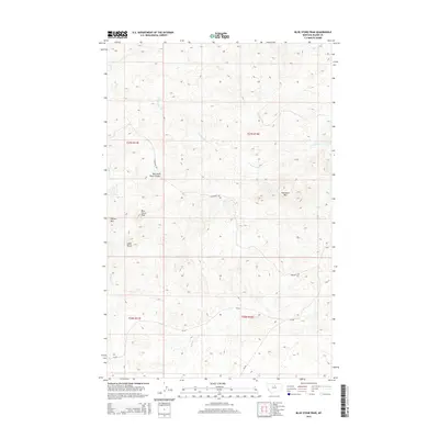
2014 Map of Blue Stone Peak
USGS Topo · Published 2014About this map
Blue Stone Peak and the surrounding high country of Blaine County define this section of the Montana landscape. This 2014 survey captures a terrain marked by distinctive geological formations such as Elkhorn Mtn and Index Butte, which serve as prominent landmarks in an area dominated by deep drainages and coulees. The complex drainage network includes the West Fork Black Coulee and the headwaters of Sand Cr, S Fork Cow Cr, and Volcano Cr. Transportation through this isolated rangeland is limited to a few arterial routes, most notably Sawtooth Rd, which skirts the base of Sawtooth Mtn. The map's township and range boundaries, including t27n r17e and t26n r18e, underscore the systematic land division characteristic of the American West, providing a clear framework for those studying land use and property records in the northern plains.
Find a feature on this map
16 named features on this map. Tap any name to fly to it.
Don’t see what you’re looking for? This feature index may not catch every label — zoom into the map to look around manually.
Map Details
Editions of this 2014 Blue Stone Peak Map
This is the sole edition of this map. No revisions or reprints were ever made.
Other maps of this area

1953 · Havre
USGS Topo · 1:250,000

1954 · Lewistown
USGS Topo · 1:250,000

1956 · Maddux
USGS Topo · 1:62,500

1957 · Havre
USGS Topo · 1:250,000

1958 · Havre
USGS Topo · 1:250,000

1959 · Lewistown
USGS Topo · 1:250,000

1959 · Warrick
USGS Topo · 1:62,500
1984 · Eskay NE
USGS Topo · 1:24,000

1984 · Big John Butte
USGS Topo · 1:24,000
1984 · Warrick
USGS Topo · 1:24,000