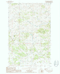
1987 Map of Blue Stone Peak
USGS Topo · Published 1987About this map
Sawtooth Mountain and Blue Stone Peak dominate this corner of Blaine County, where the high plains rise into prominent peaks and ridges. The landscape is defined by the drainages of South Fork Cow Creek and West Fork Black Coulee, which cut through the complex topography of the Bearpaw Mountains. Numerous springs are marked across the terrain, indicating vital water sources for the cattle ranching operations that utilize this land. Evidence of local land use is visible in the network of unimproved roads leading to a Corral and several underground pipelines that traverse the township lines. Along the western edge, the slopes of Elhorn Mountain and the distinctive Index Butte provide navigational landmarks. This 1980s-era study documents the drainage patterns of Sand Creek and the intricate contour intervals of the mountain front, offering a clear record of the watershed and ranching infrastructure.
Find a feature on this map
12 named features on this map. Tap any name to fly to it.
Don’t see what you’re looking for? This feature index may not catch every label — zoom into the map to look around manually.
Map Details
Editions of this 1987 Blue Stone Peak Map
This is the sole edition of this map. No revisions or reprints were ever made.
Other maps of this area

1953 · Havre
USGS Topo · 1:250,000

1954 · Lewistown
USGS Topo · 1:250,000

1956 · Maddux
USGS Topo · 1:62,500

1957 · Havre
USGS Topo · 1:250,000

1958 · Havre
USGS Topo · 1:250,000

1959 · Lewistown
USGS Topo · 1:250,000

1959 · Warrick
USGS Topo · 1:62,500
1984 · Eskay NE
USGS Topo · 1:24,000

1984 · Big John Butte
USGS Topo · 1:24,000
1984 · Warrick
USGS Topo · 1:24,000