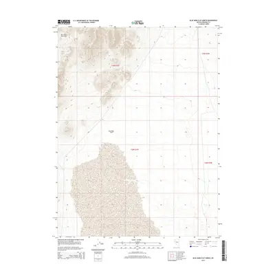
2014 Map of Blue Wing Flat North
USGS Topo · Published 2014About this map
Blue Wing Mountains dominate the northwestern quadrant of this Pershing County landscape, their steep contours descending sharply into the expansive desert sink of Blue Wing Flat. This 2014 survey illustrates a stark, arid basin defined by significant elevation changes between the high mountain peaks and the broad, level floor of the flat below. The map detail highlights the intricate drainage patterns that characterize this portion of the Great Basin, where seasonal runoff carves narrow channels from the heights toward the valley floor. The land is precisely divided by the Public Land Survey System, including sections within t29n r27e and t28n r27e, reflecting the orderly grid of the American West superimposed over an unforgiving and primarily undeveloped geological environment.
Find a feature on this map
6 named features on this map. Tap any name to fly to it.
Don’t see what you’re looking for? This feature index may not catch every label — zoom into the map to look around manually.
Map Details
Editions of this 2014 Blue Wing Flat North Map
This is the sole edition of this map. No revisions or reprints were ever made.
Other maps of this area

1886 · Granite Range
USGS Topo · 1:250,000

1894 · Granite Range
USGS Topo · 1:250,000

1931 · Lovelock
USGS Topo · 1:250,000

1935 · Lovelock
USGS Topo · 1:250,000

1955 · Lovelock
USGS Topo · 1:250,000

1959 · Lovelock
USGS Topo · 1:250,000
1981 · Bluewing Flat South
USGS Topo · 1:24,000

1981 · Twin Buttes Well
USGS Topo · 1:24,000

1981 · Bluewing Flat North
USGS Topo · 1:24,000
1981 · Seven Troughs
USGS Topo · 1:24,000