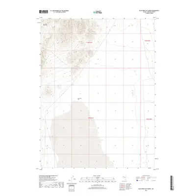
2018 Map of Blue Wing Flat North
USGS Topo · Published 2018About this map
The Blue Wing Mountains dominate the northwestern quadrant of this Pershing County landscape, their steep contours descending sharply toward the expansive alkali desert. This high-elevation terrain gives way to the broad, level expanse of Blue Wing Flat, a characteristic Great Basin playa that covers the southern half of the map. The stark contrast between the ridgelines and the basin floor illustrates the classic basin and range topography of northern Nevada. This 2018 survey serves as a precise record of the public land survey system divisions across the region, including townships t29n r27e, t29n r28e, t28n r27e, and t28n r28e, which define the administrative boundaries in this sparsely populated interior.
Find a feature on this map
6 named features on this map. Tap any name to fly to it.
Don’t see what you’re looking for? This feature index may not catch every label — zoom into the map to look around manually.
Map Details
Editions of this 2018 Blue Wing Flat North Map
This is the sole edition of this map. No revisions or reprints were ever made.
Other maps of this area

1886 · Granite Range
USGS Topo · 1:250,000

1894 · Granite Range
USGS Topo · 1:250,000

1931 · Lovelock
USGS Topo · 1:250,000

1935 · Lovelock
USGS Topo · 1:250,000

1955 · Lovelock
USGS Topo · 1:250,000

1959 · Lovelock
USGS Topo · 1:250,000
1981 · Bluewing Flat South
USGS Topo · 1:24,000

1981 · Twin Buttes Well
USGS Topo · 1:24,000

1981 · Bluewing Flat North
USGS Topo · 1:24,000
1981 · Seven Troughs
USGS Topo · 1:24,000