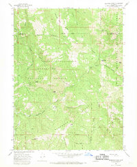
1967 Map of Bluenose Ridge
USGS Topo · Published 1969About this map
The Round Valley Indian Reservation Bdy and the Old Indian Treaty Boundary intersect across this mid-century landscape, marking historical jurisdictional shifts in the northern California wilderness. Situated within the Mendocino National Forest, the terrain is dominated by prominent landforms such as Bluenose Ridge and Bean Ridge, which flank the deep drainages of Cardenas Creek and Pepperwood Creek. The map documents a sparsely settled region where human activity is limited to remote sites like Brown Ranch, Lightning Camp, and Salt Rock Camp.
Find a feature on this map
35 named features on this map. Tap any name to fly to it.
Don’t see what you’re looking for? This feature index may not catch every label — zoom into the map to look around manually.
Map Details
Editions of this 1967 Bluenose Ridge Map
4 editions found
Other maps of this area

1920 · Covelo
USGS Topo · 1:62,500

1921 · Hoaglin
USGS Topo · 1:62,500

1922 · Island Mountain
USGS Topo · 1:62,500

1926 · Covelo
USGS Topo · 1:62,500

1931 · Hoaglin
USGS Topo · 1:96,000

1935 · Hoaglin
USGS Topo · 1:125,000

1952 · Spyrock
USGS Topo · 1:62,500

1952 · Covelo
USGS Topo · 1:62,500

1953 · Blackrock Mtn
USGS Topo · 1:62,500

1954 · Blackrock Mtn
USGS Topo · 1:62,500