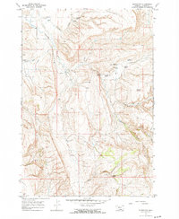
1967 Map of Bluewater
USGS Topo · Published 1972About this map
The Bluewater Fish Hatchery is a central focal point of this Carbon County landscape, situated at the confluence of several hydrologic features in the late 1960s. The map illustrates a high desert environment where water management is critical, shown through the network of the O'Connor Ditch and Orchard Ditch. These irrigation efforts, coupled with a series of wells such as Ruckavina Well No 2 (Flowing) and Ruckavina Well No 3, reveal the mid-century intersection of ranching and early petroleum or water exploration in the Bluewater Creek drainage.
Find a feature on this map
28 named features on this map. Tap any name to fly to it.
Don’t see what you’re looking for? This feature index may not catch every label — zoom into the map to look around manually.
Map Details
Editions of this 1967 Bluewater Map
2 editions found
Other maps of this area

1954 · Billings
USGS Topo · 1:250,000

1956 · Bridger
USGS Topo · 1:24,000

1956 · Fromberg
USGS Topo · 1:24,000

1956 · Edgar
USGS Topo · 1:24,000

1957 · Billings
USGS Topo · 1:250,000

1958 · Billings
USGS Topo · 1:250,000

1967 · Section House Draw
USGS Topo · 1:24,000

1967 · Bluewater
USGS Topo · 1:24,000
1967 · Pryor NW
USGS Topo · 1:24,000

1969 · Bowler
USGS Topo · 1:24,000