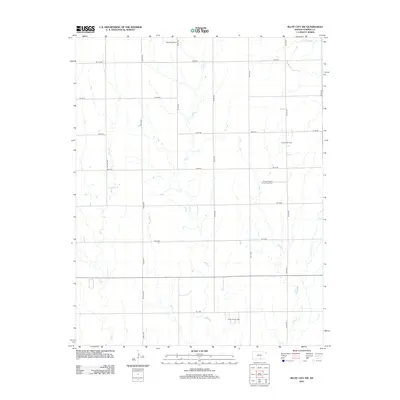
2012 Map of Bluff City NW
USGS Topo · Published 2012About this map
The Freeport Oil Field and the Freeport South Oil and Gas Field dominate the eastern landscape of this 2012 survey, signaling the persistent role of petroleum extraction in rural Harper County. The terrain is structured by a rigorous grid of section-line roads, including Ne 50 RD and Berlin Rd, which divide the vast agricultural tracts typical of south-central Kansas. Interspersed among these modern thoroughfares are natural drainage systems such as Silver Cr and Rock Cr, which meander southward across the township lines. Aviation interests are represented by the Kaypod Airport in the northern portion of the quadrangle, while the presence of the Stohrville Oil Field near the southern boundary further underscores the area's industrial character. This map documents a landscape defined by the intersection of traditional Kansas agriculture and the infrastructure of the energy sector.
Find a feature on this map
25 named features on this map. Tap any name to fly to it.
Don’t see what you’re looking for? This feature index may not catch every label — zoom into the map to look around manually.
Map Details
Editions of this 2012 Bluff City NW Map
This is the sole edition of this map. No revisions or reprints were ever made.
Other maps of this area

1889 · Anthony
USGS Topo · 1:125,000

1889 · Caldwell
USGS Topo · 1:125,000

1891 · Anthony
USGS Topo · 1:125,000

1893 · Caldwell
USGS Topo · 1:125,000

1897 · Caldwell
USGS Topo · 1:125,000

1955 · Wichita
USGS Topo · 1:250,000

1955 · Pratt
USGS Topo · 1:250,000

1958 · Wichita
USGS Topo · 1:250,000

1959 · Pratt
USGS Topo · 1:250,000
1971 · Bluff City West
USGS Topo · 1:24,000