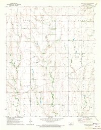
1971 Map of Bluff City NW
USGS Topo · Published 1973About this map
The Missouri Pacific railroad cuts a diagonal path through this portion of Harper County, serving as the primary infrastructure artery for the rural landscape. In the early 1970s, the region was defined by a balance of agriculture and energy extraction, evidenced by the clustered wells of the Stohrville Oil Field, the Freeport Oil Field, and the Freeport South Oil and Gas Field. Local aviation is represented by private facilities like Kaypod Landing Field and the Salser Landing Strip, which dot the open country. The terrain is marked by distinctive elevations such as Pilot Knob and Odell, while the drainage system of Silver Creek and Baehr Creek flows southward toward the Berlin township line. This survey captures the specialized infrastructure of the Kansas oil patch during a period of active production.
Find a feature on this map
14 named features on this map. Tap any name to fly to it.
Don’t see what you’re looking for? This feature index may not catch every label — zoom into the map to look around manually.
Map Details
Editions of this 1971 Bluff City NW Map
This is the sole edition of this map. No revisions or reprints were ever made.
Other maps of this area

1889 · Anthony
USGS Topo · 1:125,000

1889 · Caldwell
USGS Topo · 1:125,000

1891 · Anthony
USGS Topo · 1:125,000

1893 · Caldwell
USGS Topo · 1:125,000

1897 · Caldwell
USGS Topo · 1:125,000

1955 · Wichita
USGS Topo · 1:250,000

1955 · Pratt
USGS Topo · 1:250,000

1958 · Wichita
USGS Topo · 1:250,000

1959 · Pratt
USGS Topo · 1:250,000
1971 · Bluff City West
USGS Topo · 1:24,000