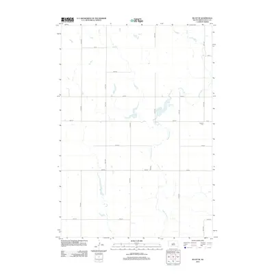
2012 Map of Blunt NE
USGS Topo · Published 2012About this map
Medicine Knoll Cr meanders through this portion of Sully County, defining a landscape primarily organized by the rigid grid of the Public Land Survey System. The area is dominated by agricultural section lines, with numbered routes like 183 St and 320th Ave providing the primary framework for movement across the plains. In the eastern portion of the quadrangle, Durrstein Lake provides a notable hydrologic break in the prairie, surrounded by subtle topographic depressions typical of the region's glacial legacy. For genealogists and local historians, the Pleasant Cem serves as a significant landmark, situated near the intersection of 186th St and 320th Ave. This survey documents a quiet rural landscape where the placement of small cemeteries and the flow of seasonal creeks remain the primary features among the sprawling section-line roads.
Find a feature on this map
17 named features on this map. Tap any name to fly to it.
Don’t see what you’re looking for? This feature index may not catch every label — zoom into the map to look around manually.
Map Details
Editions of this 2012 Blunt NE Map
This is the sole edition of this map. No revisions or reprints were ever made.
Other maps of this area

1953 · Huron
USGS Topo · 1:250,000

1954 · Huron
USGS Topo · 1:250,000

1967 · Blunt
USGS Topo · 1:24,000

1967 · Blunt SE
USGS Topo · 1:24,000
1967 · Blunt NW
USGS Topo · 1:24,000

1967 · Blunt NE
USGS Topo · 1:24,000

1968 · Harrold NW
USGS Topo · 1:24,000

1968 · Harrold
USGS Topo · 1:24,000

1974 · Gettysburg Municipal Airport SE
USGS Topo · 1:24,000
1974 · Gettysburg Municipal Airport SW
USGS Topo · 1:24,000