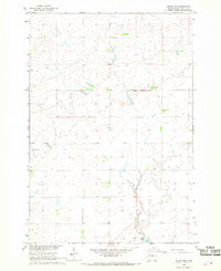
1967 Map of Blunt NW
USGS Topo · Published 1968About this map
Blaine Sch stands as a focal point in this sparsely populated agricultural landscape of Sully County during the late 1960s. The terrain is defined by a complex network of intermittent drainages and natural depressions, with Post Lake situated in the southern portion of the quadrangle. This 1967 field-checked survey reveals the deliberate organization of the land into townships and ranges, including T. 114 N. and T. 113 N., where scattered wells and unimproved dirt roads suggest a reliance on localized water sources and seasonal farming access. A designated Landing Area reflects the integration of light aviation into the rural economy, likely for crop management or transport across these expansive prairie tracts. The map provides a clear look at the drainage patterns flowing toward the Missouri River Basin, detailing the subtle elevation changes that shaped local land use and infrastructure.
Find a feature on this map
7 named features on this map. Tap any name to fly to it.
Don’t see what you’re looking for? This feature index may not catch every label — zoom into the map to look around manually.
Map Details
Editions of this 1967 Blunt NW Map
This is the sole edition of this map. No revisions or reprints were ever made.
Other maps of this area

1953 · Huron
USGS Topo · 1:250,000

1954 · Pierre
USGS Topo · 1:250,000

1954 · Huron
USGS Topo · 1:250,000

1958 · Pierre
USGS Topo · 1:250,000

1965 · Agar
USGS Topo · 1:24,000

1967 · Onida SE
USGS Topo · 1:24,000

1967 · Blunt
USGS Topo · 1:24,000

1967 · Blunt SE
USGS Topo · 1:24,000

1967 · Blunt NE
USGS Topo · 1:24,000

1974 · Gettysburg Municipal Airport SE
USGS Topo · 1:24,000