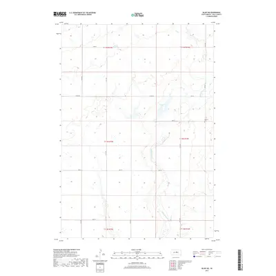
2017 Map of Blunt NE
USGS Topo · Published 2017About this map
Medicine Knoll Cr meanders across this rural landscape in Sully County, defining the drainage patterns through the section lines north of Blunt. The terrain is characterized by a sparse network of section-line roads, including E Onida Rd and 320th Ave, which carve out the high plains of the Missouri Plateau. A notable landmark for family historians is Pleasant Cem, situated in the eastern portion of the quadrangle near the crossing of 186th St. To the north, Durrstein Lake occupies a low-lying basin, reflecting the glacial pothole topography common to this region of South Dakota. This 2017 survey shows the enduring geometry of the Public Land Survey System, with township lines like t115n r74w marking the organized agricultural grid that has shaped the area since the homesteading era.
Find a feature on this map
20 named features on this map. Tap any name to fly to it.
Don’t see what you’re looking for? This feature index may not catch every label — zoom into the map to look around manually.
Map Details
Editions of this 2017 Blunt NE Map
This is the sole edition of this map. No revisions or reprints were ever made.
Other maps of this area

1953 · Huron
USGS Topo · 1:250,000

1954 · Huron
USGS Topo · 1:250,000

1967 · Blunt
USGS Topo · 1:24,000

1967 · Blunt SE
USGS Topo · 1:24,000
1967 · Blunt NW
USGS Topo · 1:24,000

1967 · Blunt NE
USGS Topo · 1:24,000

1968 · Harrold NW
USGS Topo · 1:24,000

1968 · Harrold
USGS Topo · 1:24,000

1974 · Gettysburg Municipal Airport SE
USGS Topo · 1:24,000
1974 · Gettysburg Municipal Airport SW
USGS Topo · 1:24,000