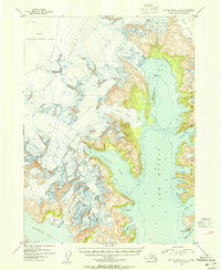
1953 Map of Blying Sound D-8
USGS Topo · Published 1954About this map
The Harding Icefield dominates the western half of this mid-century survey, a high-altitude glacial mass that feeds several massive ice flows into the complex fjords of the southern Kenai Peninsula. Glacial giants including the Aialik Glacier, Holgate Glacier, and Pederson Glacier are shown at their 1950s extent, calving into deep marine waters like Aialik Bay and Holgate Arm. The coastline is remarkably intricate, defined by the jagged Aialik Peninsula and Harris Peninsula. This landscape, much of it protected within the Kenai National Moose Range, provides a detailed record of coastal geomorphology before modern climatic changes altered the glacial termini. Coastal features such as Quicksand Cove and Mc Mullen Cove sit at the feet of the Kenai Mountains, where the ice meets the sea.
Find a feature on this map
25 named features on this map. Tap any name to fly to it.
Don’t see what you’re looking for? This feature index may not catch every label — zoom into the map to look around manually.
Map Details
Editions of this 1953 Blying Sound D-8 Map
2 editions found
Other maps of this area

1944 · Kenai
USGS Topo · 1:250,000

1946 · Blying Sound
USGS Topo · 1:250,000

1950 · Kenai
USGS Topo · 1:250,000

1950 · Seward A-8
USGS Topo · 1:63,360

1950 · Blying Sound D-7
USGS Topo · 1:63,360

1950 · Seward A-7
USGS Topo · 1:63,360

1951 · Blying Sound
USGS Topo · 1:250,000

1951 · Seward
USGS Topo · 1:250,000

1951 · Seldovia
USGS Topo · 1:250,000

1951 · Seward A-7
USGS Topo · 1:63,360