
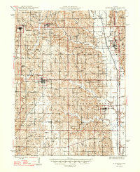
1947 Map of Blythedale
USGS Topo · Published 1947About this map
The Chicago Burlington and Quincy railroad cuts a vital corridor through Harrison County, linking established farming hubs like Ridgeway and Blythedale. This mid-century landscape is defined by its high density of rural infrastructure, featuring an extensive network of schoolhouses such as Green Castle Sch, Prairie Chapel Sch, and Shawbell Sch. These community nodes, alongside churches like Mt Olive Ch and Sharon Ch, reflect a highly organized agricultural society before the consolidation of rural districts.
Find a feature on this map
69 named features on this map. Tap any name to fly to it.
Don’t see what you’re looking for? This feature index may not catch every label — zoom into the map to look around manually.
Map Details
Editions of this 1947 Blythedale Map
2 editions found
Other maps of this area

1925 · Pattonsburg
USGS Topo · 1:62,500

1925 · Gilman
USGS Topo · 1:62,500

1944 · Pattonsburg
USGS Topo · 1:62,500

1945 · Mount Ayr
USGS Topo · 1:62,500

1945 · Lamoni
USGS Topo · 1:62,500

1946 · Gilman
USGS Topo · 1:48,000

1946 · Pattonsburg
USGS Topo · 1:48,000

1946 · Princeton
USGS Topo · 1:62,500

1947 · Lamoni
USGS Topo · 1:62,500

1947 · Mount Ayr
USGS Topo · 1:62,500