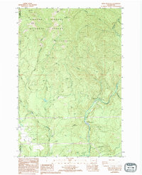
1986 Map of Bobs Mountain
USGS Topo · Published 1994About this map
Gifford Pinchot National Forest dominates this landscape in the mid-1980s, where the high peaks of the Cascade Range transition into deep river valleys. The extraction history of Skamania County is evident through the presence of the Skamania Mine and Last Chance Mine, alongside numerous Borrow Pits that suggest local infrastructure development. At the higher elevations, the Silver Star Indian Pits near Silver Star Mtn provide a connection to the area's indigenous history and land use. The water network is central to the area's character, anchored by the Washougal River and the Washougal State Salmon Hatchery. Recreational and social sites are well-documented, from the Dougan Creek Campground and Dougan Falls to Camp Melacoma, reflecting the region's mid-century shift toward forest-based recreation and conservation. The map also captures the varied terrain of Bobs Mountain and the distinct open space of Bear Prairie.
Find a feature on this map
38 named features on this map. Tap any name to fly to it.
Don’t see what you’re looking for? This feature index may not catch every label — zoom into the map to look around manually.
Map Details
Editions of this 1986 Bobs Mountain Map
2 editions found
Other maps of this area

1918 · Troutdale
USGS Topo · 1:62,500

1934 · Troutdale
USGS Topo · 1:48,000

1940 · Lookout Mtn
USGS Topo · 1:62,500

1941 · Yacolt
USGS Topo · 1:62,500

1941 · Camas
USGS Topo · 1:62,500

1942 · Camas
USGS Topo · 1:62,500

1948 · Vancouver
USGS Topo · 1:250,000

1950 · Vancouver
USGS Topo · 1:250,000

1950 · Vancouver
USGS Topo · 1:250,000

1953 · Lookout Mtn
USGS Topo · 1:62,500