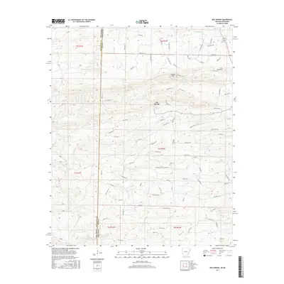
2017 Map of Bog Springs
USGS Topo · Published 2017About this map
The settlement of Bog Springs sits at the heart of this landscape, situated along the border of Polk County, Arkansas and McCurtain County, Oklahoma. This 2017 survey reveals a complex network of forest and county roads, such as Polk Road 14 and Polk Road 16, which navigate the high-elevation terrain of the Cross Mountains. To the north, Whiskey Peak rises above the surrounding valleys, while Twin Springs and Hickory Creek drain the northern slopes. The mapping of Oak Grove Cemetery east of the main settlement provides a specific point of interest for genealogists tracing local families. Numerous small waterways, including Indian Creek, Rough Creek, and Cedar Branch, carve through the ridges, reflecting the drainage patterns of this border region where the Ouachita Mountains define the local geography and transportation routes.
Find a feature on this map
73 named features on this map. Tap any name to fly to it.
Don’t see what you’re looking for? This feature index may not catch every label — zoom into the map to look around manually.
Map Details
Editions of this 2017 Bog Springs Map
This is the sole edition of this map. No revisions or reprints were ever made.
Other maps of this area

1902 · Lukfata
USGS Topo · 1:125,000

1913 · De Queen
USGS Topo · 1:125,000

1950 · Mcalester
USGS Topo · 1:250,000

1959 · Cove
USGS Topo · 1:62,500

1959 · Broken Bow
USGS Topo · 1:62,500

1960 · Smithville
USGS Topo · 1:62,500

1962 · McAlester
USGS Topo · 1:250,000

1964 · Gillham
USGS Topo · 1:24,000

1965 · McAlester
USGS Topo · 1:250,000
1966 · De Queen NW
USGS Topo · 1:24,000