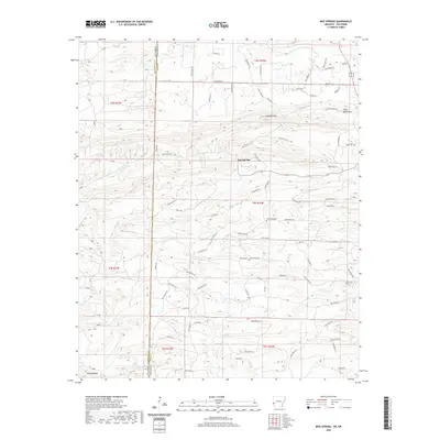
2020 Map of Bog Springs
USGS Topo · Published 2020About this map
Bog Springs sits at the heart of this landscape, positioned along the state line where Oklahoma and Arkansas meet. The geography is defined by a series of distinct heights, including Whiskey Peak and the Cross Mountains to the north, and Williams Mtn in the south. This modern survey illustrates a network of forestry roads and county routes, such as Polk Road 16 and Co Rd 425, which navigate the drainages of Indian Creek and Cross Creek. Local history is anchored at Oak Grove Cemetery, while the varied water sources like Twin Springs and Hickory Creek provide a clear view of the area's natural hydrology. The layout of these features demonstrates how local settlements and transit paths have adapted to the ridge-and-valley system of the Ouachita region.
Find a feature on this map
73 named features on this map. Tap any name to fly to it.
Don’t see what you’re looking for? This feature index may not catch every label — zoom into the map to look around manually.
Map Details
Editions of this 2020 Bog Springs Map
This is the sole edition of this map. No revisions or reprints were ever made.
Other maps of this area

1902 · Lukfata
USGS Topo · 1:125,000

1913 · De Queen
USGS Topo · 1:125,000

1950 · Mcalester
USGS Topo · 1:250,000

1959 · Cove
USGS Topo · 1:62,500

1959 · Broken Bow
USGS Topo · 1:62,500

1960 · Smithville
USGS Topo · 1:62,500

1962 · McAlester
USGS Topo · 1:250,000

1964 · Gillham
USGS Topo · 1:24,000

1965 · McAlester
USGS Topo · 1:250,000
1966 · De Queen NW
USGS Topo · 1:24,000